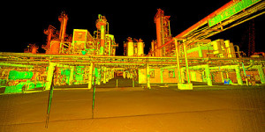
 Thoroughly understanding the complex intricacies involved in the functionality of 3D scanners is not entirely necessary for the client. However, it may be beneficial to have a generalized understanding of how these lasers solve problems and streamline the process for civil engineers and landscape architects, alike.
3D laser scanning is progressively evolving into standardized ways within the industry to systematically capture key metrics due to the laser’s precision and speed – the turnaround time is optimized with heightened accuracy. The return on laser integration is nearly immediate, especially when you consider the massive amounts of data that can be accessed using this technique.
But the question still remains. How exactly do these things work? And how scientifically complicated does the process actually get?
How 3D laser scanning works
Detailed documentation is acquired through the non-invasive projections of the laser. As we outlined on our site, “a 3D laser scanner emits a narrow, eye-safe laser beam that sweeps across a target area, such as a bridge, roadway or building, gathering millions of closely spaced measurements (points with a unique X, Y, and Z, value) in a matter of minutes. These scanned measurements are collected and grouped into a comprehensive point cloud database that can be easily manipulated on a standard desktop or laptop computer.” (For more applicable information regarding 3D laser scanning, click this link)
Once this data has been captured, it can be rotated and intricately analyzed just like the more traditional 3D CAD system models. The early implementation and utilization of laser scanning during the initial project phase conveniently allows for granular projections, predicators, strategic planning, and analytical measurements to be accurately and effectively acquired beforehand, thus mitigating project related risks
Our expansive 3D Laser Scan team at McNeil Engineering is comprised of both technical and specialized experts fully capable of navigating through industry related nuances and structuring the process in personalized detail for the particular need of the individual client – on a per project basis.
The use of these HD (high definition) lasers provide various service offerings that include, record surveys, 2D isometric drawings and 3D CAD models, all used to make project implementation more accurate and efficient on your behalf.
Let’s dive a bit deeper, shall we?
3D laser scanners secure data by combining the use of two particular pieces of information being projected and receptive at the same time. Simply put, we are talking about a laser in conjunction with a rotating camera, and a mirror needed for navigating the laser beam.
Next, the software paired with this procedure takes into account the distance between the camera and point of the laser to begin building the geometrical 3D model for analysis. Procedurally speaking, this means that the software must accurately detect where the line of the laser fell based on the captured images. In theory this is relatively simple – in reality, the software needs to be adaptive and sophisticated.
You may see some lasers utilize a repetitive flash, or an on / off trace. This gives the scanner viable reference between the laser light and other light that could affect the accuracy of the model.
Did you know that single scans are typically insufficient as far as providing the data needed to build a comprehensive and accurate model? Multiple scans are needed and then comparatively evaluated to produce the most precise metrics possible for the best outcome.
Other types of 3D scanning
For referencing and resourceful purposes, the list below encompasses a few of the various types of 3D laser scanning available today:
- The 3D Laser Scanner (this is the type we are predominantly referencing within this article today)
- Stereo Vision and Photogrammetry Scanning
- Structured Light Scanning
- Time of Flight Scanning ( d = c * t / 2 )
- Triangulation Scanning (the camera and laser form the baseline of the triangle, the laser and object for scanning form the right angle, and the camera and the object form the long side of the triangle)
- Point Clouds and Registration Scanning
The use of these specific methods listed here are based on each project’s specific needs, projected uses and technology readily available.
Conclusion
We get it, lasers and the technology required to ascertain specific model metrics can be a daunting task to attempt to absorb, but we hope this article gives you some basic takeaways and allowed you to understand the basic flow of how 3D laser scanning works.
If you are still unsure, don’t worry, this is where we come in. If you have any questions at all regarding an upcoming project you may have, or would like more information on sifting through the complexities of 3D laser scanning, reach out to us today. We would love to chat with you!


