 In late August, Hurricane Laura formed in the Atlantic Ocean, quickly becoming a deadly Category 4 storm. Over the course of nine days, the hurricane wreaked havoc on the state of Louisiana, leaving nearly 80 people dead and more than $14 billion in damage and destruction in its wake. When all was said and done, Laura tied with an 1856 storm for the strongest hurricane ever to hit Louisiana.
On Aug. 22, Laura made landfall in the southwestern portion of the state, damaging the facilities at Westlake Chemical near Lake Charles. The extent of the damage was unknown, so the Westlake team called McNeil Engineering to perform an assessment. We were on the next flight out to see how we could assist.
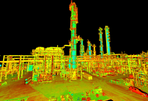
Upon arrival, our team deployed the latest and greatest in LIDAR (Light Detection and Ranging) technology to survey the damage. We set up the camera and scanning equipment to provide LIDAR scans within just a couple of days of the storm.
Due to its remote sensing capabilities, LIDAR is a technology McNeil Engineering has successfully used on projects in recent years. The technology uses a pulsed laser to create extremely precise 3D renderings of a specific area. It has been used by NOAA and other governmental agencies to help with emergency responses after disasters have hit.
In the end, we were successful in keeping the crew and local communities safe from any problems the hurricane might have caused. It is our highest priority to always provide a professional and precise product for our clients. Thanks to the Westlake Chemical team for enlisting McNeil and placing their trust in us during these challenging times.


